
Ward Maps and Boundaries
Introductory Blurb
Lorem ipsum dolor sit amet, consectetur adipiscing elit, sed do eiusmod tempor incididunt ut labore et dolore magna aliqua. Ut enim ad minim veniam, quis nostrud exercitation ullamco laboris nisi ut aliquip ex ea commodo consequat. Duis aute irure dolor in reprehenderit in voluptate velit esse cillum dolore eu fugiat nulla pariatur. Excepteur sint occaecat cupidatat non proident, sunt in culpa qui officia deserunt mollit anim id est laborum.
Resources
- Manitoba School Boards - School Board Elections
- City of Winnipeg - 2026 Municipal Council and School Boards Election
Role of the Trustees
The Winnipeg School Division Board of Trustees is established as a corporation under the terms of the Public Schools Act of Manitoba. The Board of Trustees is responsible for providing adequate school accommodation in the most enabling environment for the resident persons who have the right to attend school; employing teachers and personnel that WSD may require and prescribing their duties; and for determining the number, grade and description of schools to be established and maintained. The Board of Trustees is responsible for setting policy under which WSD operates and determining the level of the annual budget. The Board is comprised of nine trustees who the local residents elect.
The decisions made by a school board at its meetings set the overall directions and policy for the school division. The school board employs administrators to see that this direction is implemented effectively and efficiently and for the day-to-day operation of the school division.
Trustees shall serve as the Board of Trustees of Winnipeg School Division and when acting as a Board, all of the powers, duties, and responsibilities as are set out in the Public Schools Act, its Regulations, and any other act of the Province of Manitoba applicable to the Boards of Trustees of school divisions.
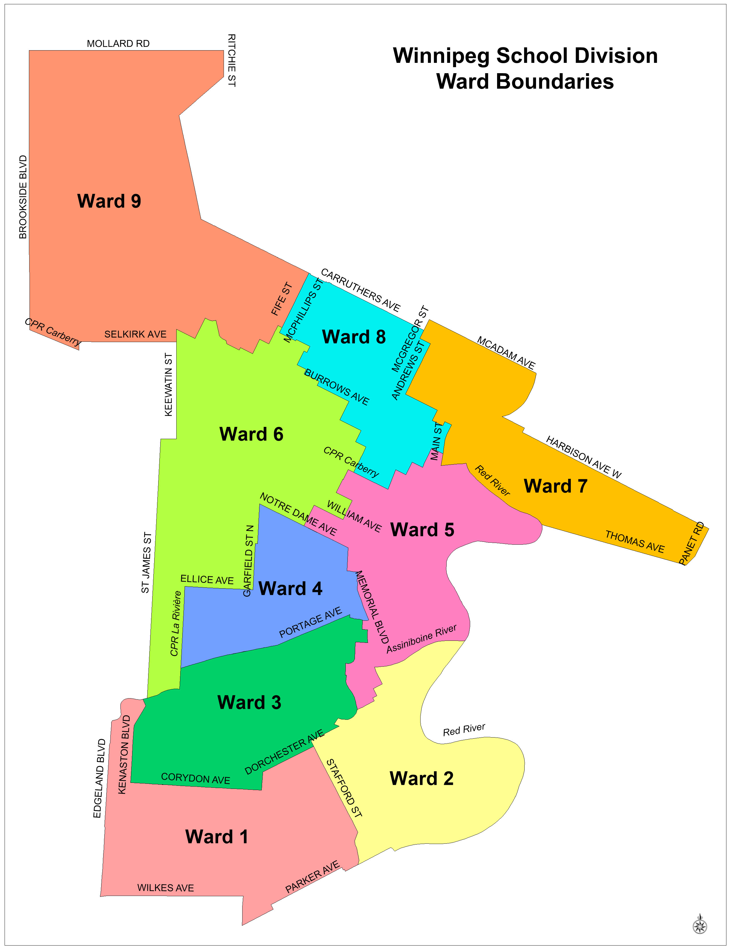
2026 WSD Ward Maps and Boundaries
Ward 1
Ward 1 includes the following schools:
- Brock Corydon School (N-6)
- Grant Park High School (7-12)
- Harrow School (N-6)
- École J.B. Mitchell School (K-6)
- Montrose School (N-6)
- Rockwood School (N-6)
- École Sir William Osler (N-7)
To see an enlarged version of the Ward 1 map, click here.
Ward 1 Boundary Description
From South Division boundary (Wilkes Ave), north on extension of Morpeth Blvd, north along Morpeth Blvd, continue north along Edgeland Blvd to Assiniboine River, east along Assiniboine River to Kenaston Blvd, south along Kenaston Blvd to Corydon Ave, east along Corydon Ave to Cambridge St, north along Cambridge St to Dorchester Ave, east along Dorchester Ave to Stafford St, south along Stafford St to Pembina Hwy, south along Pembina Hwy to South Division boundary (south side of Parker Ave), west along extension of Parker Ave (south side) to Wynne St, north along Wynne St to Parker Ave, west along Parker Ave to Heatherdale Ave, north along Heatherdale Ave to South Division boundary (north side of Parker Ave), west along South Division boundary (north side of Parker Ave) to Hurst Way, south along Hurst Way to extension of Victor Lewis Drive, west along extension of Victor Lewis Drive to Waverley St, north along Waverley St to Wilkes Ave, west along Wilkes Ave to extension of Morpeth Blvd (Division boundary).
Ward 2
Ward 2 includes the following schools:
- Collège Churchill High School (7-12)
- Early Grey School (N-8)
- Fort Rouge School (N-6)
- Gladstone School (N-6)
- École LaVérendrye (N-6)
- Lord Roberts School (N-6)
- École Riverview School (N-6)
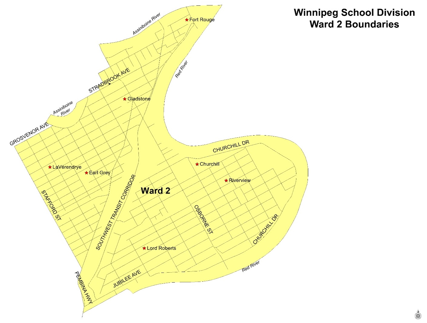
To see an enlarged version of the Ward 2 map, click here.
Ward 2 Boundary Description
From South Division boundary (south side of Jubilee Ave), north along Pembina Hwy to Stafford St, north along extension of Stafford St, continue north on Stafford St to Grosvenor Ave, east on Grosvenor Ave to Wellington Cres., north west along Wellington Cres. to 393 Wellington Crescent, north along the boundary between 393 & 475 Wellington Cres. to the Assiniboine River, east along the Assiniboine River to continuation of Stradbrook Ave (cross between 141 & 155 Wellington Crescent), continue east along Stradbrook Ave to Nassau St N, east to Norquay St (north of Stradbrook Ave), north along Norquay St to River Ave, east along River Ave to Osborne St, north along Osborne St to the Assiniboine River, east along the Assiniboine River to the Red River, south along the Red River to the South Division boundary (south of Jubilee Ave), west along south side of Jubilee Ave to Pembina Hwy.
Ward 3
Ward 3 includes the following schools:
- Carpathia School (N-6)
- Gordon Bell High School (7-12)
- Grosvenor School (N-6)
- École Secondaire Kelvin High School (9-12)
- École Laura Secord School (N-6)
- Mulvey School (N-6)
- Queenston School (N-6)
- École River Heights School (7-8)
- Robert H. Smith School (N-6)
- Wolseley School (Little Bluestem School effective September 2026) (N-6)
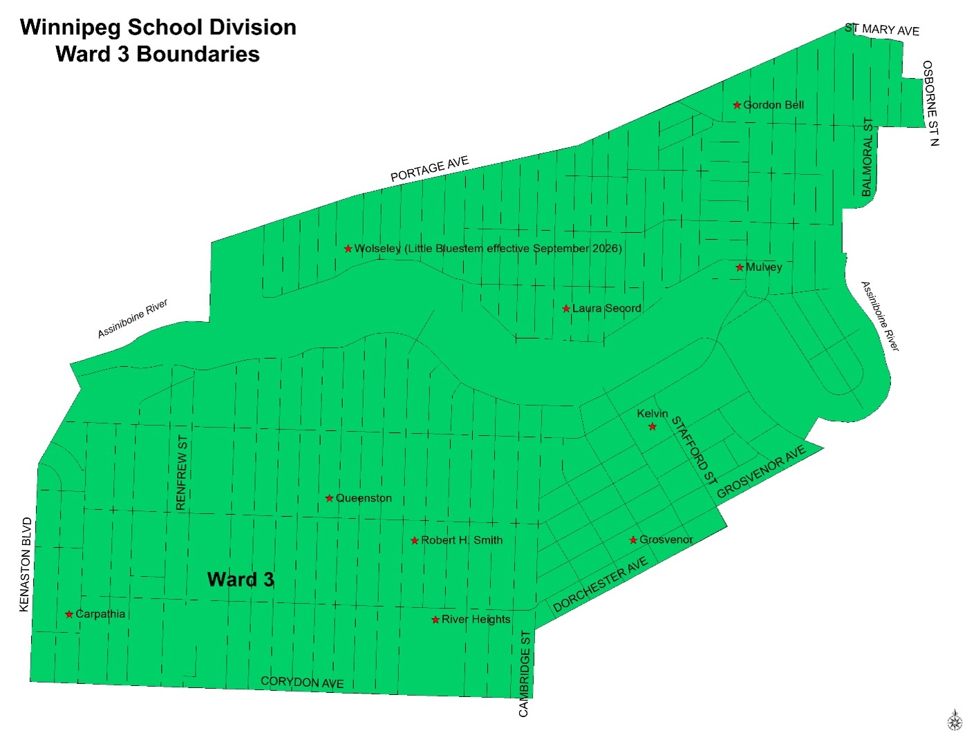
To see an enlarged version of the Ward 3 map, click here.
Ward 3 Boundary Description
From Corydon Ave, north along Kenaston Blvd to Assiniboine River, east along Assiniboine River to CPR La Rivière, north along CPR La Rivière to Portage Ave, east along Portage Ave to Spence St, south along Spence St to St. Mary Ave, east along St. Mary Ave to Colony St, south along Colony St to York Ave, east on York Ave to Osborne St N., south on Osborne St N. to Broadway, west on Broadway to Balmoral St, south on Balmoral St to Young St, south on Young St (both sides; include 75-85 Young St), continue along extension of Young St to Assiniboine River, south along Assiniboine River to extension of Wellington Ave (cross between 141 & 155 Wellington Crescent), south east along Wellington Cres to Grosvenor Ave, south west along Grosvenor Ave to Stafford St, south on Stafford St to Dorchester Ave, south west along Dorchester Ave to Cambridge St, south along Cambridge St to Corydon Ave, west along Corydon Ave to Kenaston Blvd.
Ward 4
Ward 4 includes the following schools:
- Daniel McIntyre Collegiate Institute (9-12)
- General Wolfe School (7-9)
- Greenway School (N-6)
- Isaac Brock School (N-9)
- John M. King School (N-6)
- Principal Sparling School (N-6)
- Wellington School (N-6)
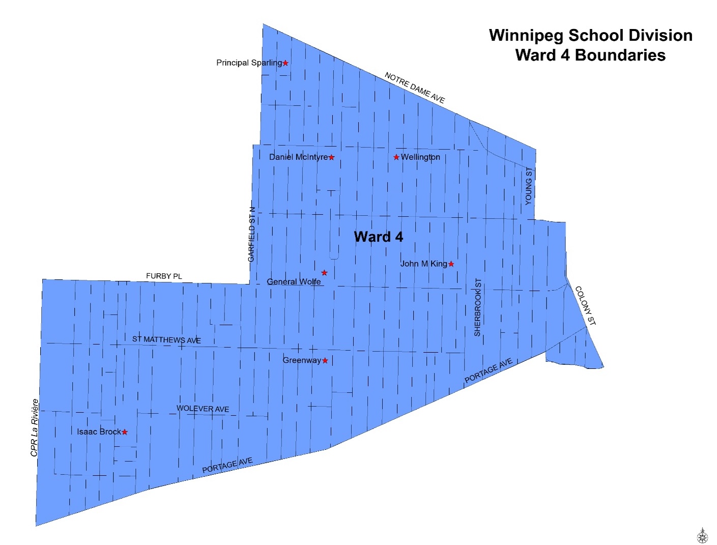
To see an enlarged version of the Ward 4 map, click here.
Ward 4 Boundary Description
From Portage Ave, north along CPR La Rivière to Ellice Ave, east on Ellice Ave to Garfield St N., north on Garfield St N. (includes addresses on the west side) to Wellington Ave, continue north on Garfield St N. to Notre Dame Ave, south east on Notre Dame Ave to Young St, south on Young St to Sargent Ave, east on Sargent Ave to Balmoral St, south on Balmoral St to Ellice Ave, continue south along Colony St to Portage Ave, continue south along Memorial Blvd to St. Mary Ave, west on St. Mary Ave to Spence St, north on Spence St to Portage Ave, west along Portage Ave to CPR La Rivière
Ward 5
Ward 5 includes the following schools:
- Argyle High School (9-12)
- David Livingstone School (N-8)
- Dufferin School (N-6)
- Hugh John Macdonald School (7-9)
- Norquay School (N-8)
- R.B. Russell Vocational High School (9-12)
- École Sacré-Coeur (N-8)
- Sister MacNamara School (N-6)
- École Victoria-Albert School (N-6)
- Winnipeg Adult Education Centre (10-12)
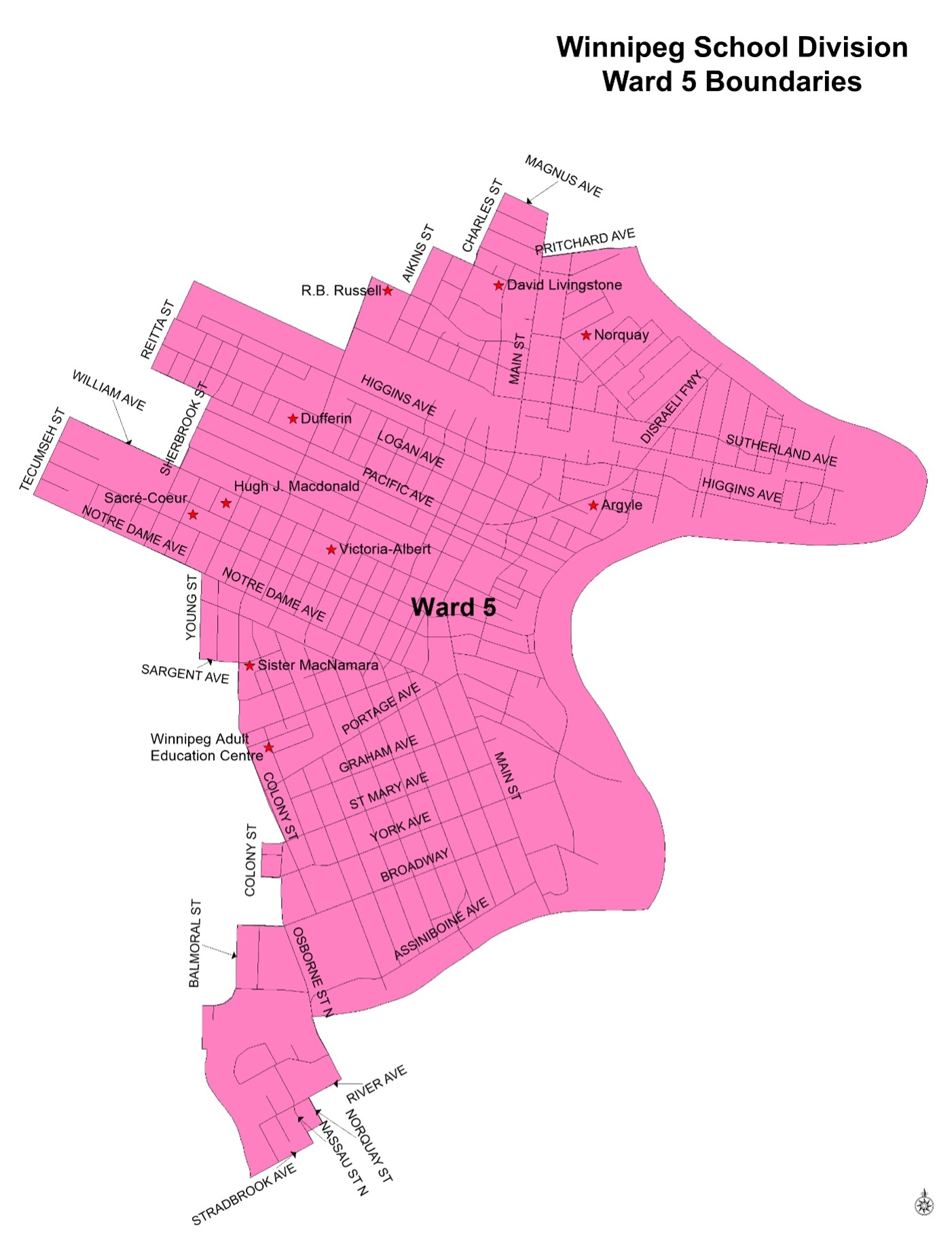
To see an enlarged version of the Ward 5 map, click here.
Ward 5 Boundary Description
From extension of Stradbrook Ave, north along Assiniboine River to extension of Young St, continue north along Young St to Balmoral St (excluding addresses 75-85 on Young St), north on Balmoral St to Broadway, east on Broadway to Osborne St N., north on Osborne St N. to York Ave, west on York Ave to Colony St, north on Colony St to St. Mary Ave, east on St. Mary Ave to Memorial Blvd, north on Memorial Blvd to Portage Ave, continue north on Colony St to Ellice Ave, continue north on Balmoral St to Sargent Ave, west on Sargent Ave to Young St, north on Young St to Notre Dame Ave, north west on Notre Dame Ave to Tecumseh St, north on Tecumseh St to William Ave, south east on William Ave to Sherbrook St, north on Sherbrook St to Alexander Ave, north west on Alexander Ave to Reitta St, north on Reitta St to Henry Ave, continue north along extension of Reitta St (cross between 753 & 769 Henry Ave) to CPR Carberry, south east along CPR Carberry to Salter St, north along Salter St to Dufferin Ave, east along Dufferin Ave to Aikins St, north on Aikins St to Flora Ave, east on Flora Ave to Charles St, north on Charles St to Magnus Ave, east on Magnus Ave to Main St, south on Main St to Pritchard Ave, east on Pritchard Ave, continue east along extension of Pritchard Ave to Red River, south along Red River to Assiniboine River, west along Assiniboine River to Osborne St, south along Osborne St to River Ave, west along River Ave to Norquay St, south along Norquay St to back lane, west on back lane to Nassau St N., south on Nassau St N. to Stradbrook Ave, west on Stradbrook Ave, continue west along extension of Stradbrook Ave to Assiniboine River (cross between 141 & 155 Wellington Ave).
Ward 6
Ward 6 includes the following schools:
- Clifton School (N-6)
- Keewatin Prairie Community School (N-8)
- King Edward School (N-6)
- Lord Nelson School (N-6)
- Pinkham School (N-6)
- Sargent Park School (N-8)
- Technical Vocational High School (9-12)
- Weston School (N-6)
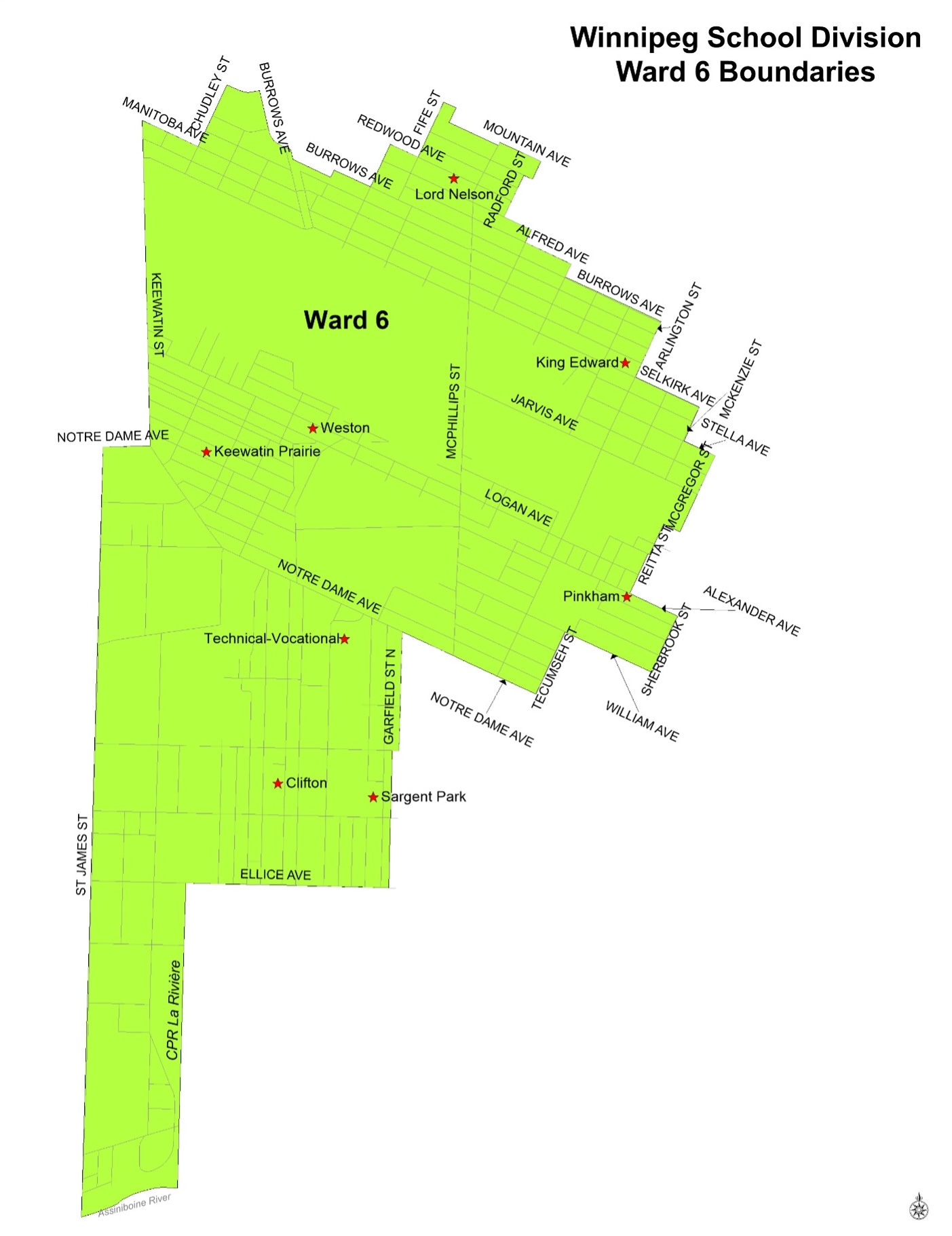
To see an enlarged version of the Ward 6 map, click here.
Ward 6 Boundary Description
From Assiniboine River, north along extension of St. James St, continue north on St. James St to Notre Dame Ave, east on Notre Dame Ave to Keewatin St, north along Keewatin St to Manitoba Ave, east on Manitoba Ave to Chudley St, north on Chudley St to Tyndall Ave, east on Tyndall Ave to Burrows Ave, south east on Burrows Ave to CPR Arborg, continue south east along Burrows Ave to Lawrence St (exclude addresses 1430 to 1496 on Burrows Ave between CPR Arborg & Lawrence St), continue east along Burrows Ave to Shaughnessy St (include addresses 1344 to 1422 on Burrows Ave), north on Shaughnessy St to Redwood Ave, south east on Redwood Ave to Fife St, north on Fife St to Troy Ave, south east on Troy Ave to boundary behind 1117 Fife St, south along boundary to Mountain Ave, south east on Mountain Ave to McPhillips St, north on McPhillips St to Mountain Ave, south east on Mountain Ave to Radford St, south on Radford St to College Ave, west on College Ave to Radford St, south on Radford St to Aberdeen Ave, south east on Aberdeen Ave to Sgt Tommy Prince St, south on Sgt Tommy Prince St to Alfred Ave, south east on Alfred Ave to Battery St, south on Battery St to Burrows Ave, south east on Burrows Ave to Arlington St, south on Arlington St to Selkirk Ave, south east on Selkirk Ave to McKenzie St, south on McKenzie St to Stella Ave, south east on Stella Ave to McGregor St, south on McGregor St, continue along extension of McGregor St to CPR Carberry, west along CPR Carberry, south along extension of Reitta St (cross between 753 & 769 Henry Ave), south along Reitta St to Alexander Ave, south east along Alexander Ave to Sherbrook St, south along Sherbrook St to William Ave, north west along William Ave to Tecumseh St, south along Tecumseh St to Notre Dame Ave, north west along Notre Dame Ave to Garfield St N., south along Garfield St N. to Wellington Ave, continue south along Garfield St N. (excluding addresses on Garfield St N.) to Ellice Ave, west along Ellice Ave to CPR La Rivière, south along CPR La Rivière to Assiniboine River, west along Assiniboine River to extension of St. James St.
Ward 7
Ward 7 includes the following schools:
- Champlain School (N-6)
- Elmwood High School (7-12)
- École George V School (N-8)
- Glenelm School (N-6)
- Kent Road School (N-6)
- Lord Selkirk School (N-6)
- École Luxton School (N-8)
- Machray School (N-6)
- River Elm School (N-6)
- St. John's High School (7-12)
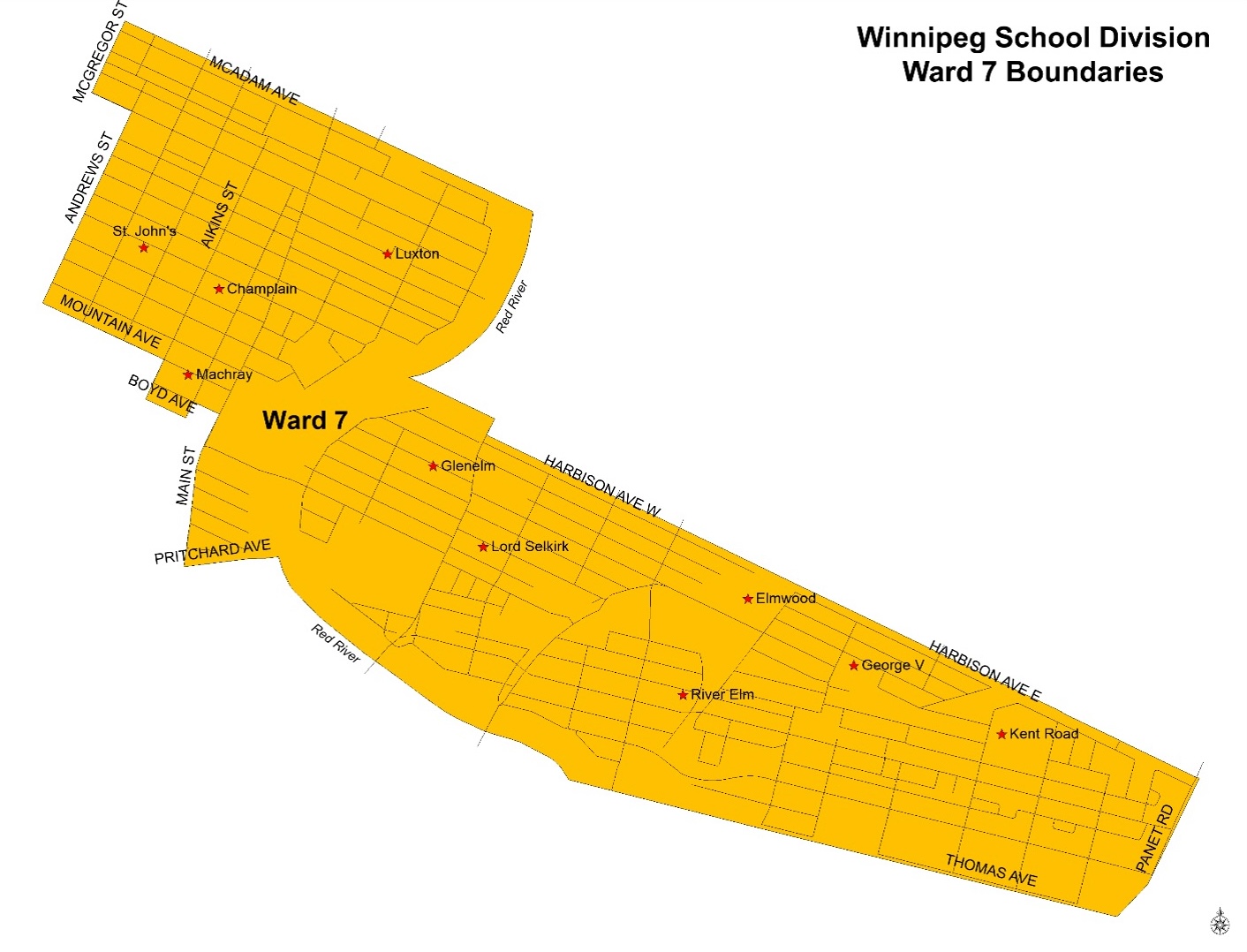
To see an enlarged version of the Ward 7 map, click here.
Ward 7 Boundary Description
From Pritchard Ave, north on Main St to College Ave, north west on College Ave to Charles St, south on Charles St to Boyd Ave, north west on Boyd Ave to Aikins St, north on Aikins St to Mountain Ave, north west on Mountain Ave to Andrews St, north on Andrews St to Inkster Blvd, north west on Inkster Blvd to McGregor St, north on McGregor St to North Division boundary (north side of McAdam Ave), east along North Division boundary to Red River, south along Red River to Elmwood Park, east along North Division boundary of Elmwood Park to Henderson Hwy, south along Henderson Hwy to Harbison Ave W, east along Harbison Ave W (both sides) and Harbison Ave E (both sides) (Division boundary), continue east along extension of north side of Harbison Ave E to Panet Rd, south along Panet Rd to Division boundary (south of Thomas Ave extension), west along Division boundary (south of Thomas Ave) to Red River, north along Red River to extension of Pritchard Ave, west on Pritchard Ave to Main St.
Ward 8
Ward 8 includes the following schools:
- Andrew Mynarski V.C. School (7-9)
- Children of the Earth High School (9-12)
- Faraday School (N-6)
- Inkster School (N-6)
- Isaac Newton School (7-9)
- École Lansdowne (N-8)
- Niji Mahkwa School (N-8)
- Ralph Brown School (N-8)
- Robertson School (N-6)
- Strathcona School (N-6)
- William Whyte School (N-8)
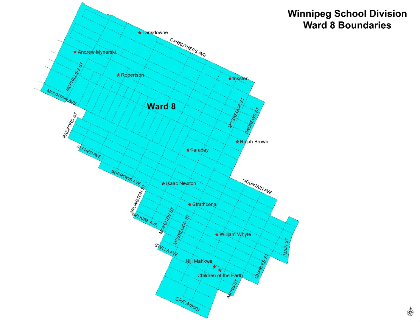
To see an enlarged version of the Ward 8 map, click here.
Ward 8 Boundary Description
From Mountain Ave, north along Fife St (excluding addresses on Fife St) to north boundary of properties on Lansdowne Ave, south east along north division property of Lansdowne Ave to McPhillips St, continue south east along Carruthers Ave to McGregor St, south along McGregor St to Inkster Blvd, east on Inkster Blvd to Andrews St, south along Andrews St to Mountain Ave, south east on Mountain Ave to Aikins St, south on Aikins St to Boyd Ave, south east on Boyd Ave to Charles St, north on Charles St to College Ave, south east on College Ave to Main St, south on Main St to Magnus Ave, west on Magnus Ave to Charles St, south on Charles St to Flora Ave, west on Flora Ave to Aikins St, south on Aikins St to Dufferin Ave, west on Dufferin Ave to Salter St, south on Salter St to CPR Carberry, west on CPR Carberry to extension of McGregor St, north along extension of McGregor St, continue north on McGregor St to Stella Ave, west on Stella Ave to McKenzie St, north on McKenzie St to Selkirk Ave, west on Selkirk Ave to Arlington St, north on Arlington St to Burrows Ave, west on Burrows Ave to Battery St, north on Battery St to Alfred Ave, west on Alfred Ave to Sgt Tommy Prince St, north on Sgt Tommy Prince St to Aberdeen Ave, west on Aberdeen Ave to Radford St, north on Radford St to College Ave, east on College Ave to Radford St, north on Radford St to Mountain Ave, west on Mountain Ave to McPhillips St, south on McPhillips St to Mountain Ave, west on Mountain Ave to Fife St.
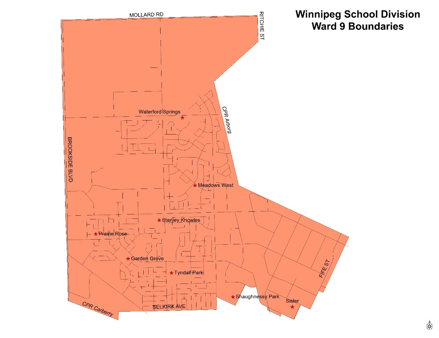
Ward 9
Ward 9 includes the following schools:
- École Garden Grove School (N-6)
- Meadows West School (N-8)
- Prairie Rose School (N-6)
- Shaughnessy Park (N-8)
- École Secondaire Sisler High School (9-12)
- École Stanley Knowles School (N-8)
- Tyndall Park School (N-6)
- École Waterford Springs School (N-8)
To see an enlarged version of the Ward 9 map, click here.
Ward 9 Boundary Description
From Mountain Ave, north along Fife St (excluding addresses on Fife St) to north boundary of properties on Lansdowne Ave, south east along north division property of Lansdowne Ave to McPhillips St, continue south east along Carruthers Ave to McGregor St, south along McGregor St to Inkster Blvd, east on Inkster Blvd to Andrews St, south along Andrews St to Mountain Ave, south east on Mountain Ave to Aikins St, south on Aikins St to Boyd Ave, south east on Boyd Ave to Charles St, north on Charles St to College Ave, south east on College Ave to Main St, south on Main St to Magnus Ave, west on Magnus Ave to Charles St, south on Charles St to Flora Ave, west on Flora Ave to Aikins St, south on Aikins St to Dufferin Ave, west on Dufferin Ave to Salter St, south on Salter St to CPR Carberry, west on CPR Carberry to extension of McGregor St, north along extension of McGregor St, continue north on McGregor St to Stella Ave, west on Stella Ave to McKenzie St, north on McKenzie St to Selkirk Ave, west on Selkirk Ave to Arlington St, north on Arlington St to Burrows Ave, west on Burrows Ave to Battery St, north on Battery St to Alfred Ave, west on Alfred Ave to Sgt Tommy Prince St, north on Sgt Tommy Prince St to Aberdeen Ave, west on Aberdeen Ave to Radford St, north on Radford St to College Ave, east on College Ave to Radford St, north on Radford St to Mountain Ave, west on Mountain Ave to McPhillips St, south on McPhillips St to Mountain Ave, west on Mountain Ave to Fife St.